Categories
- Aircraft, Helicopter, UAV, Spacecraft & related equipment
GEOAMBIENTE, is a Consulting Engineering Company which aggregates knowledge and value to the business of its clients using GEOTECHNOLOGIES. With a solid experience of many years in the market and professionals with multi-disciplinary background, GEOAMBIENTE always aims to innovation, and it is known as one of the main geotechnology companies in Brazil.
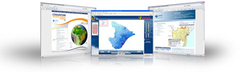
The Company's GIS-IT team develops complete Information Technology Solutions focused on a geographic view. GEOAMBIENTE is a partner of the main market players, such as ESRI and GOOGLE, accumulating in its portfolio several success cases on the conception, development, integration and implementation of corporative GIS systems.
The Company's specialists in Remote Sensing, Cartography and Environmental Analysis developed intelligent solutions for thematic and plani-altimetric mapping, data integration, analysis of multi-varied information and environmental management. The Company applies its knowledge from Geosciences, acting on several market segments, always aiming to create innovative responses and optimized solutions for the needs of its clients. The success of its partnerships with the image distributors Space Imaging, DigitalGlobe and RapidEye, as well as the supply of TeleAtlas databases, guarantee the efficiency of its business model.
GEOAMBIENTE is committed to the excellence of business processes of its clients, with both social-environmental sustainability and the best practices for the development of complete solutions in geotechnologies. GEOAMBIENTE is continually performing significant and growing investments on the development of its System for Quality Management. It is a set of activities and corporative procedures which ensure that GEOAMBIENTE fully complies with the requirements of its clients, of the regulating agencies and of the society, on a structured and monitored way, aligned with the best market practices.
The Company is continuously improving its corporative processes, such as the introduction of strategic planning, using the Balanced Scorecard Pattern, the good practices of Capability Maturity Model Integration (CMMI) for the development of systems, an efficient project management based on the PMBOK, besides the quality control by sampling selection, directed by ABNT (Brazilian Association for Technical Standards), among other actions.
The good performance and quality actions extrapolate the technical area and attain all sectors of the company. Since GEOAMBIENTE exerts an efficient and responsible financial management, it is registered and certified at the database of D&B (Dun & Bradstreet), which is one of the most respected entities for the financial qualification of companies worldwide.
In practice, the excellence at Service Quality is a commitment from GEOAMBIENTE
Contact info #1
Contact info #2
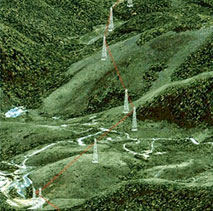
DEFENCE & INTELLIGENCE
The fast and easy access to updated and reliable geo-spatial information is indispensable for military and civilian intelligence organizations to perform strategic activities, such as:
-
Planning and management of missions which involve the displacement of large contingents;
-
Management of crisis situations;
-
Systematic reconnaissance and monitoring of strategic areas;
-
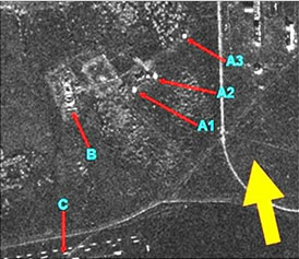
Identification and detailed characterization of targets of interest (ships, buildings and illegal landing strips for airplanes).
Radar remote sensing is an important source of geo-spatial data which can be acquired at a high temporal frequency, independently of extensive cloud coverage, allowing precise analysis and detailed information.
GEOAMBIENTE offers solutions for Defense and Intelligence applications with systems that allows the configuration of imaging parameters in accordance with the project objectives as well as with the acquisition and availability of data, easily and in almost real-time, considering that imaging of the area can be done in 2,5 days.
Among the various advantages we can highlight: high geometric and radiometric accuracy; multi-polarization; easily programmable with different resolutions, different incidence angles and viewing azimuths.
GEOAMBIENTE offers several services and products for the Defense and Intelligence segments, detaching among them:
-
Basic images at different processing levels (non-geocoded, geocoded, complex);
-
Ortho-rectified images without control points with position accuracy compatible with PEC A(*) down to scale 1:10,000;
-
Contour lines and Digital Elevation Models without control points, with vertical accuracy compatible with PEC A at scale 1:50,000;
-
Detection of change services and monitoring of strategic areas;
-
Detection services of targets of interest;
-
Plani-altimetric mapping (contour lines, drainage and transportation system) compatible with PEC A at scale 1:25,000.
(*) PEC is the Brazilian abbreviation for Cartographic Standard for Accuracy, a quality reference for maps.
The Geographic Information Systems (GIS) developed by GEOAMBIENTE are also excellent tools for use in these intelligence areas. Among the different functionalities, these systems allow the simulation of different events to plan actions during crisis or emergency conditions and help also on the localization of victims in risk areas for urgent evacuation.
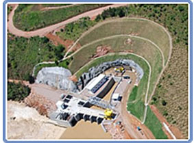
ENERGY
Planning, implantation and management of engineering works for hydro-electric power plants and transmission lines demands technical, environmental and social-economic knowledge, generating a large amount of data and information. The analysis of these aspects, are best evaluated when they are made under a spatial and temporal view, using geotechnologies and GIS.
Since GEOAMBIENTE has a highly specialized team and due to its great experience in this segment, it is able to:
Study the feasibility and project
Integrated study to subsidy the definition of the lineation from the transmission line, preliminary determination of the water level and inundation area, using remote sensing. Survey and organization of data in GIS, for environmental studies. We deliver cartography and topography for studies and projects for hydroelectric use, according to guidelines of ANEEL (Brazilian National Agency for Energy). Environmental licensing, supply of satellite images, Digital Elevation Models (DEM) and general thematic maps.
Installation of the undertaking
Environmental management during the installation phase of power plants and transmission lines. Social-economic cadastre and physical properties cadastre; patrimony evaluation and dominion study; negotiation of servitude for the transmission of power line and annotation of constituted servitude; organization and remittance of DUP process (Declaration of Public Utility). Environmental licensing of the power transmission line and hydro-electric plants and PCHs (Small Hydro-Electric Power Plants). Implantation and management of basic environmental projects conditioned to installation license; control and implantation of marks and execution of basic cartography.
Operation of the undertaking
Monitoring occupation of the servitude strip under the power transmission line and edges of the water reservoir (area of permanent protection). Development of GIS to control the patrimony; characterization and control of erosion at the edges of reservoirs; studies and actions for the reforestation and recovery of the edges from the reservoir. Monitoring of suspended sediments and macro-phytes in reservoirs. Survey and structuring of the geographic data collection.
Environmental management
Integrated management of environmental control and compensation program of energy undertakings for generation and transmission of power, involving activities of monitoring and control from the execution of environmental programs; management and quality control of corresponding products and services; representation of the client at environmental agencies; preparation of a geographic databank; obtainment and renovation of environmental licenses; environmental monitoring and control during the installation phase of undertakings and support to implant a system for environmental management during the operation phase.
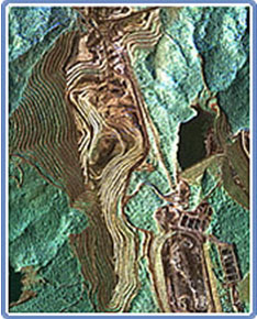
MINING
Geotechnology can be used during all phases of mineral exploration. The products and services of GEOAMBIENTE are valuable instruments, contributing to reduce costs and to accelerate steps from the production process, optimizing results and facilitating decision taking.
GEOAMBIENTE develops works for the prospection of areas, detailed research and planning of the mining plant, monitoring and environmental control and management of information related to the mining processes.
The Company's services are present at all phases of mineral exploration: starting at data integration and geologic mapping, during prospection, participating at the elaboration of detailed cartography for research and procedures for the implantation of mining and attendance of exploration. GEOAMBIENTE also develops Geographic Information Systems (GIS) for environmental control and management of information from mining processes, which are essential during the life cycle of the undertaking.
Some of the services and products developed by GEOAMBIENTE for mining are:
-
Supply of SAR images with up to 1m resolution;
-
Digital Surface Model and Digital Terrain Model obtained by radar without control points, with up to 5m precision;
-
Detailed cartography from stereoscopy with satellite images and field control, obtaining planimetric maps at scale 1:5,000;
-
GIS for the control of environmental licensing processes, authorization for deforestation, committments and constraints, quality control of water resources in production plants;
-
Orthorectification of images and geophysical data integration with radar or optical satellite images, radar stereoscopy and regional plani-altimetric cartography;
-
Mapping of natural vegetation for the control and to conduct procedures for environmental licensing;
-
3D models to design transverse sections and digital surfaces for geologic modeling and location of probing meshs;
-
Virtual mockup, which is an exclusive product of GEOAMBIENTE, and allows a three-dimensional visualization from satellite images or aerial photographs, with online navigation from the user over all the area of interest;
-
Monitoring of surface movements using SAR interferometry.
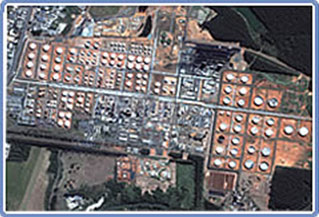
OIL & GAS
The needed activities for the exploration, production and and distribution of oil and gas require a joint analysis of a large set of data and information, such as geologic factors, sismic data, infrastructure, security of assets, inspection services, environmental data, consumer markets, distribution systems, etc.
The GIS technology, used jointly with Remote Sensing and Cartography processes, allows the incorporation of geographic information to data from the oil industry business on centralized or distributed information bases, which allows the availability of precise information in the place and time needed.
The studies for new implantations or exapansions from existing areas, as well as the analysis of consumption, maintenance and repair of distribution nets and general engineering works, require a precise, up-to-date and dynamic mapping.
Due to these demands, GEOAMBIENTE helps its clients with systems, products, tools and mechanisms for the management of the database, using geotechnologies oriented towards the continuous improvement of business processes involved, reducing time and costs, to optimize the results of our clients. Cartographic data, high resolution satellite images and radar images used jointly with geographic information systems, represent a differential in the market, aggregating value to products and services from our clients.
With a multidisciplinary and highly specialized team and using the most innovative techniques and processes, GEOAMBIENTE attends several demands of the oil and gas sector, offering fast, robust and quality solutions.
AGRIBUSINESS
One of the big challenges is to guarantee the production and the food supply for 6 billion people worldwide. In order to provide that, the production in the field must increase its efficiency and minimize the losses in the production chain, providing intelligence on the use of inputs, natural resources and food transport, maximizing the results and acting with social-environmental responsibility.
The search to solutions for the standardization and optimization of production processes, using remote sensing and GIS techniques, became a constant and a differential at the agribusiness market.
In order to comply with the demands of this sector, GEOAMBIENTE offers differentiated solutions which attend the needs of the clients. The Company's services and products help on the planning, monitoring and management of the entire production chain, with precise and updated data, optimizing resources, minimizing losses and guaranteeing lower costs. This means an increase of productivity and a higher financial return to the entrepreneurs.
Agricultural Areas
Development and implantation of agricultural management systems with an interface for geographic data; mapping and monitoring of agriculture properties; characterization of relief forms and slope; mapping of agricultural aptness and production vocation; water availability; patrimony; identification of cultures and its attendance along the entire cycle.
Forests and Reforestation
Forest planning using the advantages of images from optical sensor systems and radar, using the analysis tools of GIS and the versatility of mobile GIS for logistic optimization, planning, maintenance of roads and support to the forest inventory during all production phases.
Some of the services provided for the area of agribusiness and agro-forests:
-
Remote assessment of crops along its growing cycle;
-
Studies on agricultural aptness and characterization of areas with commercial interest;
-
Mapping of natural resources (Environmental Protection Areas [EPA], Legal Reserve(*) and water covered surfaces);
-
Mapping of hydrographic EPA, of springs, hilltops, high mountains and slopes;
-
Detailed cartography at scale 1:5,000 by satellite images – contour lines;
-
Geographic Information Systems for the elaboration of projects with environmental adequacy of rural properties;
-
Management Plan, studies for compensation of Legal Reserve;
-
Project to obtain the Environmental License of rural properties;
-
CAR – complete project for the Rural Environmental Cadastre;
-
Projects for Environmental License of agro-forestry undertakings.
(*) Special protection areas under Brazilian Law.

PUBLIC MANAGEMENT
The growing demand of population for more public services with quality, are requiring from public institutions and government sectors, alternatives to manage more efficiently the cities and States. In order to comply with these needs, managers need a far-reaching knowledge of its territory, with updated information to subsidize its decisions.
Geotechnology became an important support tool for governors and responsible technicians, because it represents the different realities existing in the municipality or State, its real social and economic potential, as well as its shortages and problems which must be solved.
The updated and precise geographic information allow public managers to define their strategic actions on a fast and safe way, optimizing costs.
GEOAMBIENTE is attentive to the needs of modern public management, offering GIS solutions for issues such as land cover and land use, tributary control and fiscal responsibility, increment of income, infrastructure and sanitation networks, mechanisms for the control of areas with restricted use, etc.
Our solutions are customized for each municipality or State and allow the total integration with the other already existing systems, propitiating the improvement of planning, monitoring and evaluation of the urban space, in compatibility with the budget conditions.
GEOAMBIENTE develops and implants modular GIS systems integrating data of different Secretaries and Departments, such as: Planning, Health, Transports, Public Works and Housing, Security, Environment, Sports and Culture, Civil Defense, etc.
Our technical team is qualified for the preparation and application of BICs (Bulletins of Cadastral Information), besides offering instruments for the control and occupation of restricted areas such as Legal Reserves, Areas of Permanent Protection, Contaminated Areas and Areas of Geo-technical Risks.
In order to load the data in GIS systems, GEOAMBIENTE executes several mappings from high resolution satellite and radar images, performing data survey in the field, using last generation equipments and software.
Using the GIS from GEOAMBIENTE, the public manager has the best information in hands to take the best decisions.
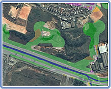
ENVIRONMENT
GEOAMBIENTE provides environmental consultancy for activities supporting undertakings in electric power, mining, agribusiness, oil and gas and water resources, acting in several large works in Brazil, during the last 15 years.
The company uses remote sensing and GIS techniques as working tools for the processes of analysis, planning and environmental management of undertakings from the different productive sectors.
The use of these tools promotes velocity, security and update of data and available information. This is an important support for strategic decision taking of companies, referring to the environment, contributing to a sustainable development and a good return to the entrepreneurs.
GEOAMBIENTE has a multi-disciplinary team which is able to elaborate those studies needed to obtain the authorizations and environmental licenses (Previous, Installation and Operation licenses) from undertakings, performing the entire management of the process with environmental agencies, saving time and money for the entrepreneurs.
GEOAMBIENTE executes several works related to Environment. We detach among them:
-
Environmental diagnosis,
-
Study on the dynamics of land use/land cover,
-
Characterization of different regeneration stages of vegetation,
-
Mapping and characterization of areas under permanent protection (APPs),
-
Environmental regularization of rural properties,
-
Elaboration of recovery plans for degraded areas (PRAD),
-
Environmental monitoring,
-
GIS for environmental adequacy of rural properties – AGROGEO,
-
Conflict management of environmental processes,
-
Forest inventory,
-
Environmental management of undertakings in general,
-
Development of GIS applications for the analysis and environmental monitoring,
-
GIS system for cadastre and management of water and soil in industrial plants.
Experience, Quality, Innovation, Attendance to terms and Fair prices are the pillars of our environment services. GEOAMBIENTE is a consulting engineering company focused in the business of its clients and promotion of sustainable development with social responsibility.
In the environmental area GEOAMBIENTE is a reference in the national Brazilian market, with proven experience and excellence in performance.

WATER RESOURCES
Brazil is known as one of the most important water patrimonys of the planet.
The country is rich in hydric resources, but due to its continental dimensions, there is a great spatial and temporal variation of flows. The watersheds located in areas which present a combination of low water availability and large use of this resource, suffer occasionally shortage and hydric stress. These watersheds need an intensive planning and management of its resources.
For an adequate planning of companies, government and institutions related to catchment, storing, distribution and water use, geotechnology became a prime technology.
The Geographic Information Systems constitute the support environment for management and to the decision-taking process, because they permit to establish indicators based on spatial analysis, besides allowing obtain, recover, transform and visualize data. This technology is being used increasingly on environmental planning with strong participation on the management of water resources.
The experience from GEOAMBIENTE in water resources comes from a large amount of projects with regional, State and national relevance. Among the works developed, there are tools which work in a GIS environment of comprehensive type, with a large number of functionalities to support the analysis and planning of water resources, hydrologic modeling, studies on hydric potential, etc.
GEOAMBIENTE is a specialized company on the development of works involving water and sewer, recommended internationally by ESRI, Environmental Systems Research Institute.
The tools developed by GEOAMBIENTE for the management of the water resources consider applications of water balance, cadastre of uses and users of hydric resources, availability, quality, grant and water use, among others.
Among the applications of hydrologic modeling, the tools for automatic delimitation of watersheds, determination of surface stream flow, determination of the inundation area, monitoring of ground water, stand out, among others.
Besides the development of GIS tools, GEOAMBIENTE also executes other relevant works on water resources, such as mapping of the drainage net, validation of the flow bend-quota using multi-temporal remote sensing, attendance of filling from reservois and monitoring of water depth with radar images, among others.
GIS IT
GIS is an interdisciplinary tool which allows the convergence of different business lines, where the space and localization are a common language. If "where" is important for your business, then GIS is your working tool. Always when "where" appears, within the questions which must be solved by an information system, there will be opportunities of gains, when using GIS.
The possibility of advanced spatial analysis, propitiated by this technology, brings great results with the use of Geoinformation to help decision taking. Being so, it is of fundamental importance that GIS technology is integrated to the different management systems used by the companies, such as ERPs, CRMs, BIs and Systems for Content Management.
GEOAMBIENTE has an experienced and specialized team of IT professionals to design the best solution for every business, using Business Process Management (BPM) and the most adequate technology for all needs.
For the development of GIS applications, GEOAMBIENTE has its Process for the Development of Software (PDS) based on the Rational Unified Process (RUP) customized and adherent to the practices of software development of the Capability Maturity Model Integration (CMMi).
For the management of projects, the Company's methodology is based on the best management practices of projects from Project Management Body of Knowledge (PMBOK©), prepared by the Project Management Institute (PMI©).

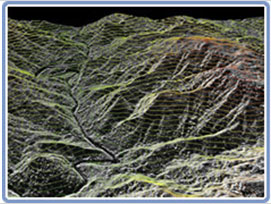
REMOTE SENSING
Remote Sensing is a set of technologies which allow monitoring of the Earth surface. Its use makes decision taking more efficient and maximizes the competitivity of companies in the most varied market segments.
GEOAMBIENTE has many years of knowledge with practical applications of remote sensing. This is reflected at a highly specialized and capable technical body for the development of intelligent solutions, directed to the needs of its clients.
The Company is upgrading with the most modern optical Sensor and SAR (Synthetic Aperture Radar) systems, as well as with the most advanced and robust methodologies available on the market, guaranteeing excellence and quality on the products and services offered.
For an efficient management of projects, the Company uses methods supported by the best practices of Project Management Body of Knowledge (PMBOK©), elaborated by the Project Management Institute (PMI©). The infrastructure and the technology park from GEOAMBIENTE are one of the best in Brazil.
GEOAMBIENTE offers remote sensing services and products with high aggregated value, such as:
- Monitoring of surface movements using SAR interferometry;
- Extraction of DEM using stereoscopy of SAR and optical images;
- Production of topographic maps from SAR and optical images;
- Digital fusion SAR/optical image, SAR/geophysics, SAR/thematic map;
- Fusion of images from optical sensor systems;
- Mapping of land use/land cover from SAR and optical high resolution images.
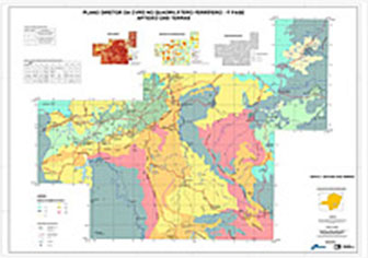
CARTOGRAPHY
Cartography delivers precise and up-to-date information and knowledge. To collect, model, store and analyze information of physical properties from the real world, which are abstracted and translated in graphical features, associated to the cartographic position of the earth, identifies the backbone of a good cartographic solution.
Cartography is a fundamental instrument for planning and decision taking, in the sectors of intelligence, defense, strategy, infrastructure, environment, energy resources, mining exploration and public agencies.
GEOAMBIENTE has a wide experience on the delivery of high quality cartographic products, directed to the needs of its clients, with intelligent solutions, practical and customized for the needs and interests of the clients.
The products and services from GEOAMBIENTE are made using the highest technologies available and they are made from consolidated processes at all phases of the project. This guarantees more speed and quality for the solutions.
The cartographic products from GEOAMBIENTE follow the directives and standards defined by CONCAR (National Cartography Commission). They can be elaborated at different scales, compatible to the Standard of Cartographic Accuracy (PEC), most adequate for each solution.
All Company's projects are managed under a project management methodology based on the best management practices of the Project Management Body of Knowledge (PMBOK©), prepared by the Project Management Institute (PMI©).
Among the various products developed by GEOAMBIENTE are the following:
-
DEM - Digital Elevation Model (Optical and radar sensors),
-
MUB - Basic Urban Map,
-
Thematic mapping (hydrography, transportation systems, land use/land cover, etc.),
-
Mapping of surface movements (interferometry by radar),
-
Cadastre for multiple use,
-
Orthorectification of images (optical and radar sensors),
-
Fusion and mosaicing of images from different sensors.
ENVIRONMENTAL MANAGEMENT
GEOAMBIENTE executes the Integrated Management of Environmental Compensation and Control Programs of Undertakings, during all the phases of work execution.
The environmental management made by GEOAMBIENTE includes all activities of monitoring and control of the execution of environmental programs, the management and quality control of products corresponding services, representation of the client-undertaker at environmental agencies, elaboration of a geographical databank with information from all the environmental programs, obtainment and renovation of environmental licenses, environmental monitoring and control during the implantation of the undertaking and support to the implantation of an Environmental Management System during the operation phase.
During the environmental management, the company acts with management processes and methods compatible with the present state of the art, and uses the most modern equipments and techniques found on the market, using geotechnologies, radar images, etc.
Some of the activities done by GEOAMBIENTE for the environmental management of undertakings are:
-
Integrated management of environmental programs foreseen in the installation and operation licenses from the undertaking;
-
Contact with environmental agencies and organization of data and documents to the obtainment and renovation of environmental licenses;
-
Social-economic cadastre and relocation of population affected;
-
Expertise and patrimony evaluation of properties and improvements;
-
Negotiation for the acquisition of properties or for the servitude of passage, including all legal procedures for the registration of these transactions at the competent government organs;
-
Use of GIS for the control of patrimony;
-
GIS for the management of environmental monitoring points and environmental programs;
-
GIS-WEB for the publication and monitoring of performance of environmental actions and commitments;
-
Environmental studies, such as EVA (Study on Environmental Feasibility), EAS (Simplified Environmental Study), RAP (Preliminary Environmental Report), EIA/RIMA (Study on Environmental Impact/Report on Environmental Impact) and PRAD (Plam for the Recovery of Degraded Areas).
The environmental management made by GEOAMBIENTE aims at guaranteeing the implantation of the undertaking, observing the actions programmed for the environmental control and compensation, without the occurrence of “non-conformities”.
To execute these services, GEOAMBIENTE has a multidisciplinary, experienced and highly qualified team, acting on the physical, biotic and social-economic specializations, aiming at the development of a broad, effective environmental management, committed with the success of the undertaking.
With proven experience on this type of work, GEOAMBIENTE guarantees rapidity, security, tranquility and substantial savings for the entrepreneurs, related to environmental aspects and questions.
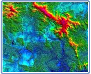
RADAR SYSTEM
RADAR system operates at different modi of imaging, polarization and incidence angle, which allows a higher flexibility to this sensor, permitting to configurate imaging according to the characteristics of the area and to the needs of the client. GEOAMBIENTE has a specialized team on this sensor, providing an enormous programming facility and an unparalleled agility for the collection and delivery of images.
The Company provides products with different levels of processing, appropriate for the several needs of the market, such as:
-
Complex images which allow to work with differential interferometry;
-
Non-geocoded images;
-
Calibrated images;
-
Orthorectified images with 5 m precision, compatible with PAC A at scale 1:25,000;
-
Mosaics from images;
-
Digital Elevation Models (DEM) with 10 m resolution and vertical accuracy between 5 and 10 m, depending on the terrain.
GEOAMBIENTE offers also a large amount of services, namely:
-
Topographic mapping,
-
Digital Surface Models (DSM),
-
Digital Terrain Models (DTM),
-
Land use/land cover mappings,
-
Deforestation mapping,
-
Monitoring of surface movements,
-
Maps of change detection,
-
Integration of radar/geophysics data, which can be customized to attend the demands and needs of the clients.
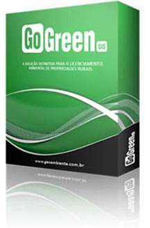
GoGreenGIS
GoGreenGIS is a GIS tool (Geographic Information System) that simplifies the whole process of environmental licensing of rural properties. With GoGreenGIS is possible to register information of properties and generate automatic analyses of vegetable covering, permanent preservation area (APP) and legal reserve (RL), automatically characterizing the real situation of rural properties by the defined criteria for RL and APP, in agreement with the current law in each Brazilian State.
It still allows the emission of printable reports and customized thematic maps that facilitate the process of environmental stabilization in competent environmental agency, propitiating a significant reduction in the final costs of the whole process.
With the automatically analyses generated by GoGreenGIS is possible to optimize the ITR (Rural Property Tax) calculation, maximizing the deductions of the tax owed to the environmental situation of the property.
With GoGreenGIS you can:
-
Spatialize the property boundaries from different data sources (geographic coordinates, UTM, Rumo/Azimuth, collection of points on map, import spreadsheets, etc.).
-
Register information regarding the properties, connect them to the geographic featureand perform spatial queries and alphanumeric queries.
-
Generate automated vegetation analysis, permanent preservation area (APP) and Legal Reserve (RL).
-
Analyze the environmental liabilities (APP, Vegetation Cover, Areas of Use, Legal Reserve) of farms.
-
Adjust the properties of legal reserves under the law by using methods of revegetation, clearing and regeneration.
-
Allocate the remnants of the properties to other uses (Authorisation of Deforestation and Forest Management).
-
Printable reports and digital documents needed to stabilize the property's environmental.
-
Generate descriptive memorandum of legal reserve and property.
-
Generate support for preparation of Recovery Plans Land Degradation in APP and Legal Reserve.
-
Generate Thematic Maps as technical specifications of the competent state agency.
-
Show the real situation of rural properties meet the criteria for RL and APP, in accordance with the laws of each Brazilian state.
Advantages and Benefits:
-
Regularization optimization of the legal reserve for several properties,
-
Generating clear reports on the environmental assessment of properties,
-
Standardization the results generated (thematic maps and reports),
-
Centralizing and organizing data on properties,
-
Agility in the generation of documents necessary for the process of regularization of Legal Reserve,
-
It allows the integration of environmental data to calculate the properties of ITR,
-
Elimination of inconsistencies between fiscal and environmental data,
-
Automates the process of declaration of ITR.
Databases:
Along with GoGreenGIS you can acquire databases to use with the software, including hydrography, property boundaries, land use, Amazon limits, vegetation, deforestation, the remaining (current and Ground Zero) etc.
Explore the options of databases:
-
Pack Hidro-top 1:50.000 - Vector files extracted from Official topographic maps at 1:50,000 scale.
-
Pack Hidro-top 1:100.000 - Vector files extracted from Official topographic maps at 1:100,000 scale.
-
Pack Hidro-IMA - The hydrography comes from mapping done through the analysis and interpretation of information contained in the satellite images at 1:50,000 scale. With support of Digital Elevation Models (DEM), systematic data mapping, etc.
-
Adequação-Client – Appropriateness of the themes of deforestation (current and ground zero), balance (current and ground zero), hydrography and land use provided by the client.
-
Adequação-Premium - Supply of the structured and complete database for GoGreenGIS.
For more information about available database, special projects or the acquisition of GoGreenGIS, please contact: NEGOCIOS@GEOAMBIENTE.COM.BR
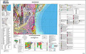
THEMATIC MAPPING
It is not enough that maps respond only to the question Where? Maps today must respond also to the questions: Why? When? Which objective? Whom? This means that they aggregate new information and that they are “self-explanatory”. All these characteristics are found on the thematic maps. The thematic maps show the spatial distribution from a large variety of qualitative and quantitative information, of specific or general places, about spatial patterns. This opens enormous opportunities for the client.
GEOAMBIENTE elaborates thematic maps from data of optical and radar images, aerial photographs, field surveys, etc. The themes mapped can be hydrography, land use, vegetation, geology, transportation systems, environmental zoning, among many others.
The Company's mapping products are made by a multidisciplinary team of highly specialized professionals using modern technologies.
GEOAMBIENTE has its own methodology, adequate tools and a high quality standard, generating its products in several scales and formats. The Company is prepared to attend large or small demands, with an adequate infrastructure to supply the needs of its clients.
All this allows GEOAMBIENTE to propitiate intelligent and practical solutions, with speed and low costs for its clients, aggregating value and flexibility at the management of their business.
TRAINING
Thinking on the best qualification of professionals on the market and also on the development of its employees, GEOAMBIENTE innovated its training system with the creation of the CTG. The Center for Training GEOAMBIENTE (CTG) offers a complete range of courses to attend every need. The Company has an adequate infrastructure, its own didactical material and qualified instructors with a large experience on the labor market.
Trainings at CTG:
-
ArcGIS Desktop – Training draft
-
ER Mapper – Training draft
Personalized training and programmatic content according to special needs. Application of specially developed exercises.
The Company offers open courses to professionals and students in general, in pre-scheduled dates and places, as well as trainings in company, including customizations, if necessary.
Geoambiente Sensoriamento Remoto Ltda.
- Av. Shishima Hifumi, n.2911 ZIP CODE: 12244 000, SP, Sao Jose dos Campos, Brazil
- +55 12 3878-6400
- negocios@geoambiente.com.br
- www.geoambiente.com.br