Categories
- Electrical, Electronics & Electro-optics
- Radar, Sonar, Navigation, Targeting, Surveillance
We are Robin Radar Systems. Technology leader in tracking and classification of small objects.
Our mission is to provide actionable information that increases safety and security for both humans and birds. And we do that by combining purpose built radars with unique software algorithms.
We achieve leadership in global niche markets by turning customers into ambassadors. And although we’re proud of our leading position, we don’t take it for granted.
Listed in the top three most innovative Dutch companies, we continue to research, develop, manufacture, and above all, innovate.
Interviews
Interview with Mr. Siete Hamminga, CEO Robin Radar Systems (March 1st, 2019) Source: Robin Radar Systems (link)
News/Press Releases
Robin Takes Off in U.S. Market with Boeing Deal
https://www.robinradar.com/press/news/robin-takes-off-in-us-market-with-boeing-deal
Robin Makes Largest C-UAS Deal to Date
https://www.robinradar.com/press/news/robin-makes-largest-c-uas-deal-to-date
Heathrow Deploys Robin Radar Systems' Counter-Drone Technology to Protect the UK's Busiest Airport
https://www.robinradar.com/press/news/heathrow-deploys-robin-radar-systems-counter-drone-technology-to-protect-the-uks-busiest-airport
Royal Netherlands Air Force Gets New Bird Radars to Help Prevent Bird Strikes
https://www.robinradar.com/press/news/royal-netherlands-air-force-gets-new-bird-radars-to-help-prevent-bird-strikes
Robin Radar supports NATO Summit in Brussels
https://www.robinradar.com/press/news/robin-radar-supports-nato-summit-security-in-brussels/
Royal Netherlands Air Force buys radars in € 7M deal
https://www.robinradar.com/press/news/royal-netherlands-air-force-buys-radars-in-7m-deal/
Robin Helps Protect India's 70th Republic Day Parade From Aerial Threats
https://www.robinradar.com/press/news/robin-helps-protect-india-s-70th-republic-day-parade-from-aerial-threats/
Contact info #1
Contact info #2
Contact info #3
Contact info #4
Service & Maintenance
Maintenance, support, modifications and training.
ELVIRA® Drone Detection Radar
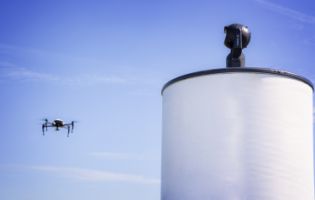
ELVIRA® combines smart software, with affordable radar, and is built explicitly for drone detection and tracking. For early warning of incoming drones, you need radar. Simply put, no other sensor technology has a wider coverage area than radar. ELVIRA® provides you with early warning of approaching drones, in all directions, giving you precious time to react.
Drone detection systems need to work in low visibility conditions, and in urban environments full of obstacles, moving objects, and a just about infinite amount of wireless radio devices.
Drones can be pre-programmed for autonomous flight with no operator and can approach in swarms. Any drone detection system should, therefore, be capable of detecting multiple targets simultaneously. And they should not rely on the drone and controller radio signals, which are only present when the drone is actively controlled.
Last but not least, any drone detector needs to distinguish drones from other moving objects, like birds, to avoid false alarms.
ELVIRA® is our purpose built drone detection radar, specifically designed to meet all of these challenges. In fact, our ELVIRA® radar is so easy to set-up and use that you'll be detecting and tracking drones within minutes.
ELVIRA's map-based interface is comprised of colour coded tracks. Red tracks indicate drones and their flight path. Orange tracks represent suspected drones. Green tracks represent birds and other moving targets. All track types can be toggled on and off, and the track visualisations and colours are all user configurable.
Google Earth imagery is used as background mapping as standard and is automatically downloaded when connected to the Internet.
You can integrate ELVIRA’s tracks and alarms as a layer in your own existing, or 3rd party, security systems and Command and Control (C2) systems. A simple XML broadcast based interface is included with ELVIRA® as standard. Other protocols, e.g. ASTERIX, are available on request.
Product informational files
2D Lite Bird Radar – most affordable bird radar
Want to avoid bird strikes on a small budget? Then our affordable 2D Lite avian radar is the solution for you.
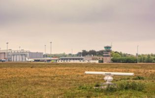
2D Lite is an entry model radar offering attractive pricing with basic performance for regional airports and small wind farms. The horizontal S-Band antenna has a peak power output of 30kW, good for a maximum range of 8km.
It detects and tracks birds, including their location, direction, speed and route, 360 degrees around, day and night. As an additional option, you can extend the functionality of the 2D Lite radar to include runway incursion warnings.
3D Fixed Bird Radar – detect and track birds in 3D
If you're looking for a 3D solution, and you're concerned with birds in a particular area, like a runway approach funnel, or a specific wind turbine(s), then 3D Fixed will do the job for you. 3D Fixed tracks birds 360 degrees around the radar in 2D, and in a fixed direction (forwards and backwards) in 3D.
The ROBIN 3D Fixed system consists of a horizontal S-band radar combined with a vertical X-band pulse radar. The horizontal S-band radar identifies the presence and number of birds in time, including their location, direction, speed and route, up to 10 kilometres away, all around, day and night.
The X-band radar covers a fixed vertical area of approximately 5 km. By combining both the horizontal and vertical images, 3D information is retrieved. This configuration is typically used in civil aviation for wildlife management and bird strike prevention at airports.
3D Flex – detect and track birds in 3D
If you need a more flexible radar, which can be configured for 3D tracking in any desired direction, 3D Flex is the radar for you.
ROBIN's 3D Flex system consists of a horizontal S-band radar, combined with a flexible Frequency Modulated Continuous Wave (FMCW) radar. The horizontal S-band radar identifies the presence and number of birds in time – including their location, height, direction, speed and route – up to 10 kilometres away, all around, day and night. The FMCW radar has three modes:
- Scanning' mode, by which 3D information is retrieved for all desired directions.
- Staring' mode, in which the radar points in one direction to identify targets up to 3.5 km away.
- Automatic Acquisition' mode, which enables targets to be locked on to and followed
The ROBIN 3D Flex offers a lot of functionality, including measuring the wing beat pattern and frequency of a single target. This provides valuable input for distinction between species. This configuration is used both in civil aviation for wildlife management and in bird strike prevention at airports, as well as for monitoring birds in offshore wind farms and for field research.
Max® Full 3D bird radar
Our flagship radar. It's taken more than four years, millions of Euros, and thousands of coffees. The result is mind-blowing. We quite simply had no other choice, but to call it Max®.
Max® has the fastest rotation speed in the market, resulting in track updates every second. This allows uniquely detailed 3D visualisation of bird flight paths, including exports to Google Earth.
Max® is a single sensor system, providing full 3D information of all birds in the nearby environment. Height information is provided for all bird tracks, and there's practically no cone of silence above the radar. Our newest bird radar offers full 3D coverage from the horizon, up to at least 1km height.
Max® has been built to monitor birds from the start. That's its entire purpose. The antennas are designed explicitly with avian targets in mind. It finally brings phased array radar technology into the hands of bird control units and ornithologists. Bird movements are displayed in real-time on a computer or mobile device (both iOS and Android).
Max® has minimal infrastructure requirements. The computer servers can be placed in already existing server rooms, meaning no shelter or housing is required at the radar location itself. All Max® needs is standard power and ethernet.
But developing new hardware isn't the only thing we've done. Because our customers often need to convert bird data into reports and KPIs, we've produced an entirely new tool, just for you. Now you can make easy to understand and appealing graphics, in a user-friendly software environment. Just select the variables and time period you want, and the tool will immediately generate impressive graphical representations.
Product informational files
Drone Detection and tracking for security & safety
You want to detect and track drones - small objects which traditional radar can’t see. And even if you’ve managed to find a radar which can see small objects, it’s unlikely it can tell birds apart from drones.
At Robin Radar Systems, we’ve specialised in detecting and tracking small objects for 33 years. Birds actually. And even though we started with tracking birds, we validated our data with drones, in order to prove our radar tracking accuracy.
So we’re in a unique position, with a wealth of experience, to detect, track, and classify (read separate) birds from drones. And that’s exactly what we’ve built ELVIRA® to do.
Where most other radars don’t provide classification of birds and drones, providing a high operator-workload, ELVIRA® does that for you, automatically.
So you can concentrate on what action to take about the unauthorised drone in your airspace.
Capabilities informational files
Bird strike prevention for aviation safety
At airports, preventing birds striking aircraft is an on-going challenge.
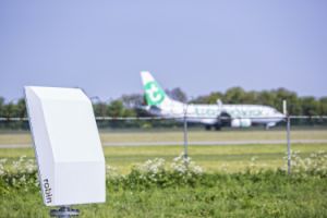
Our range of bird radars track the exact flight paths of both flocks and individual birds up to 10 kilometres.
They automatically detect and log hundreds of birds simultaneously, including their size, speed, direction and flight path.
With our avian radars, you'll be tracking in real-time, 24/7, all around your airport.
You’ll have all the information you need to mitigate bird strikes, and even intervene, when necessary.
And of course, unlike human observers, our radars don’t need to rest, and they can see in all weather, day or night.
Capabilities informational files
Bird monitoring at Wind Farms
Our bird radars are used at wind farms during both pre-construction and operational stages.
Wind farms can impact birds in the following three main ways:
- Direct habitat loss through wind farm construction;
- Displacement through indirect loss of habitat should birds avoid the new wind farm area;
- Death by collision with the turbine blades.
During pre-construction, our radars are used as a reliable and long-term measurement tool, gathering scientific data on bird movements in the area, as well as migration activity. They automatically detect and log hundreds of birds simultaneously, including their size, speed, direction and flight path.
Historically, this type of information would be gathered by human observers over one or more limited observation periods. But the long-term radar data generated by having avian radar present on-site, 24/7, is far more accurate and useful when it comes to your Environmental Impact Assessments (EIAs).
The information on bird activity, based on radar data, is compared both pre- and –post construction to measure the true impact on the local and migratory bird population.
And of course, unlike human observers, our radars don’t need to rest, and they can see in all weather, day or night.
Capabilities informational files
Amsterdam Schiphol Airport – Full bird radar coverage
The first radar was installed at Schiphol's Polder Runway in 2013. After almost three years of comprehensive trials and evaluation of our bird radar's performance, the system was extended to include an additional three 3D Flex radars.
Schiphol Airport uses Robin Radar Systems to provide full bird monitoring coverage of all of its six runways. Full coverage is achieved with four 3D Flex radars.
The first radar was installed at Schiphol's Polder Runway in 2013. After almost three years of comprehensive trials and evaluation of our bird radar's performance, the system was extended to include an additional three 3D Flex radars.
Schiphol Airport uses its radars to obtain actionable information on bird movements within 10km of its airport.
The real-time monitoring of high-risk birds, such as geese, is particularly useful in reducing the risk of bird strikes. But the long-term data gathering and analysis are also proving particularly useful as input for habitat management and generating KPIs related to reducing the risk of bird strikes.
Berlin Brandenburg Airport – trailer based 3D flex bird radar
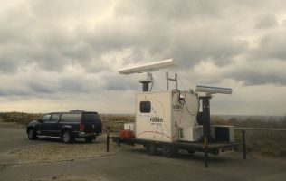
Berlin Brandenburg Airport (FBB) has a trailer based 3D Flex Radar in operation on their premises since Autumn 2016.
The Robin Radar is used to collect 24/7 relevant data about bird movements along the newly constructed Southern runway 07L/25R. The airport receives quarterly detailed reporting of the detected and recorded bird movements from the radar.
This data is combined with ground truth (field) observations by a local biologist. The combined radar and field observations will continue for a duration of five years.
EVN Group/Kavarna Wind Farm – 3D Flex Bird Radar
The wind farm Kavarna, located along the coast of the Black Sea, has particular good wind conditions, but it also happens to be in the path of a main migration route for migrating birds.
EVN Group, whose aim is to produce 50 percent of their electricity from renewable sources, wanted to utilise the excellent wind conditions of the site, but to do so in harmony with the environment and wildlife.
Siete Hamminga, of Robin Radar Systems, described the 3D Flex system that was installed at Kavarna:
"The configuration we have here in Bulgaria consists of two radars. One is a horizontal radar that monitors the birds in two dimensions and a vertical radar adds height information so that we get a 3D image of the birds. So radar allows us to monitor birds 24/7; not only during daytime but also during night time, and also in bad weather conditions, for example. So this allows us to give the bigger picture of the bird behaviour in and around the wind farm. Moreover, we monitor the bird activity around each turbine so that, for example, overnight migration will result in a shutdown of that specific turbine."
Valentin Yanchelov, Head of Environmental Affairs at EVN, described what he found important in the radar:
"The system can track the trajectory of birds. And it also provides wind information, which is very important in estimating the flight trajectory of the birds. The radar is able to track single birds as well as flocks, and can group birds by size. There are several classes of birds and the risks for each class are different. For large soaring birds, the risk of collison is significantly higher than for the smaller, more agile birds."
And the reason EVN chose Robin Radar Systems, according to EVN Project Developer, David Kadarabek?
"It's a perfect match for the site and for our project in Kavarna. Due to the possibilities, not only to be the vendor of the radar itself, but also giving us the chance for cooperation and optimisation of the radar system to the specifics of this site."
Suomen Hyötytuuli/Tahkoluoto Wind Farm – 3D Flex Bird Radar
Robin's 3D Flex radar will help Suomen Hyötytuuli measure the impact of the wind farm on the bird population as accurately as possible.
Suomen Hyötytuuli installed a mobile 3D Flex radar from Robin Radar Systems during the development of their offshore wind farm in Tahkoluoto in Pori.
Suomen Hyötytuuli's objective is two-fold:
- To measure the effects of the offshore wind farm on the bird farm population.
- To stop wind turbines automatically, when endangered species are flying nearby.
Robin's 3D Flex radar will help Suomen Hyötytuuli measure the impact of the wind farm on the bird population as accurately as possible. How?
By measuring all bird movements in and around the wind farm 24/7, both before construction and for at least 5 years after commisioning.
The radar is also being integrated with other sensors such as video cameras and infra-red cameras to improve species identification.
Together with the Tampere University of Technology, Suomen Hyötytuuli is working on having a completely automatic identification system, enabling fully automatic turbine shut down.
Meritis – ELVIRA® Drone Detection Radar
Meritis, from Switzerland, has included our ELVIRA® Drone Detection Radar in their integrated Drone Defence System.
Their full system combines radar, acoustic sensors, and cameras, for comprehensive detection, tracking and identification. It also comes with a mobile command and control (C2) unit., and a sophisticated drone jamming system is provided to neutralise any detected drones.
The jammers operate with reactive technology, which has a superior performance to only active systems. The range of jamming can be up to 10 times higher compared to only active systems.
Meritis' jammers have a sensor unit observing traffic on pre-defined frequencies. Within milliseconds the system intercepts the total traffic including encoded signals with the full available power. A system only operating with an active mode has to split the overall power capabilities.
Meritis has recently released a new rifle based portable jamming unit as an optional extra for the system.
ESG - ELVIRA® Drone Detection Radar
Commercial drones represent a serious security risk to major public events, but also to sensitive infrastructures and facilities such as indus- trial testing grounds, large industrial plants, Armed Forces properties and correctional facilities. A particular risk is the unauthorised use of such drones for espionage, provocation or even criminal and terrorist purposes.
Since early 2015, ESG Elektroniksystem- und Logistik-GmbH, Rohde & Schwarz GmbH & Co. KG, Diehl Defence GmbH have been cooperating and working intensively on a joint solution to counter these threats. The resulting solution includes different sensors and appropriate effectors as well as a command & control system. The modular drone countering solution consists of the following components:
- ESG’s TARANIS® command and control system
- R&S®ARDRONIS radio-controlled drone identification and countering system
- Diehl HPEMcounterUAS electromagnetic pulse sources
- Other optional sensors such as cameras and radars, including Robin Radar Systems' ELVIRA® Drone Detection Radar.
The cooperation ensured effective protection against the unauthorized use of commercial drones and thus against an omnipresent security risk during the 2015 G7 summit in Germany. Following its successful debut, the solution ensured the safety of other major events such as the visit of the US President to the Hanover Fair.
Adapted from: ESG Elektroniksystem- und Logistik-GmbH (2016). Modular Drone Defence System [Brochure]. Retrieved April 5, 2018, from https://www.esg.de
Robin Radar Systems
- Laan van Waalhaven 355, 2497 GM, The Hague, The Netherlands
- +31 88 7008700
- info@robinradar.com
- www.robinradar.com

